
Tuesday 13 July 2010
Wednesday 17 March 2010
horse'n'rider slideshow
just a basic slideshow, with the three images superimposed:
To get a full screen view, click on 'hnrslide3' button in bottom left corner, and chose 'slideshow'!
To get a full screen view, click on 'hnrslide3' button in bottom left corner, and chose 'slideshow'!


Monday 8 March 2010
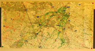
O.S. Pathfinder 420 NT26/36 Penicuik Dalkeith 1:25,000
I came across this relatively clean copy, but showing some wear and tear, with added coffee or wine stain at the bottom.
Click on the image to open full screen in new window. The image size can then be increased or decreased using 'Ctrl and + or - keys'. Use back arrow to return to this page.

The same with a few labels:

G Galachlaw
M Mavisbank earthmound
MoW The Meeting of the Waters/Lady's Seat
NA Newbattle Abbey
NC Newtongrange Church
RC Rosslyn Chapel
Sh Shewington
Friday 5 March 2010
horse and rider map: O.S. 1:25,000
Well, a week ago I couldn't get a connection between my digital camera and the computer. I checked the USB lead at both ends, but it didn't connect with the computer. Tonight nothing different, but the usual window appeared with Picasa as an option for downloading with!? I put in the main pentagonal lines which cover this map, and the blue line from Allermuir Hill to Camp Ridge, which includes both Mavisbank earthmound and Newtongrange Church. I'll cover the unfolding geometry on this line with Mavisbank as centre later!
This is the original map which I had pasted onto a board with the surrounding maps, giving me the main area of my work. A closer look will show my working lines, with many highlighted spots. It was whilst gazing at this one dispirited night, back in 1999 and asking despairingly what it was all about that it appeared to my minds eye, it was like in bas relief, the image came out of the flat surface and was so obvious, how come I had never seen it previously. Well, my best guess is, the act of sitting back gave me a detached view, and at a suitable scale, and the frame of mind was probably a contributing factor. Stunned and shocked as I was, on inspection it was astonishing, but not entirely surprising that the features were actual landscape structures, made up of estate boundary walls, with specific points of the feature marked by farms, churches, castles and even housing developments, which in effect follow the lines of the fields upon which they are situated. For example, the horses ears, are delineated by the estate of Woodburn, with the space between them taken up by a school, the playing field/playground left white, with buildings/houses in black.
I eventually coloured the feature in, mostly green for outline and any woodland incorporated. I also sketchily filled in with yellow highlighter which I think can be seen. The whole looks a bit unnaturally coloured, due to me having put a coat of clear varnish onto it when I first mounted it, to keep it clean. In retrospect that was a mistake, but not major.

Labels:
Al - Allermuir Hill
Au - Auchendinny
Car - Carberry; Tower and Hill(Queen Mary's Mount, and ancient fort)
CR - Camp Ridge(earthworks)
DHC - Dalkeith House, site of old Castle. The boundary wall forms the helmeted rider's head. Originally Douglas land, then the Buccleughs. One of whom as Earl of Dalkeith was first Grandmaster of Grand Lodge back in the 18th century.
Ea - Easthouses, village where I spent my childhood
G - Galachlaw, centre of pentagonal system.
Gl - Glencorse Old Kirk
L(SH) - The Sun Hotel, at Lothianburn. At horses chin, part of the Newbattle Boundary. The Sun was a Kerr Family symbol.
LD(SF) - Langhill Farm, Dryden Tower, and Shinbanes Field, supposedly where bones are unearthed from the Battle of Roslin. The Researh Centre responsible for Dolly The Sheep is also here. The rider's knee, along with Nivensknowe.
LK - Lasswade Kirk.
KC - Kirkton Cottage, at corner of small inner pentagon.
KG - Kings Gate, near Sherrifhall, part of Dalkeith estate wall, rider's neck.
MC - Melville Castle.
ME - Mavisbank earthmound, at back of Mavisbank House, built by Sir John Clerk of Penicuik.
MoW - The Meeting of the Waters, the riders brow, where the two Esk rivers meet. The area inside the confluence is called Lady's Seat.
NA - Newbattle Abbey, the eye of the Horse. Cistercian Abbey originally, at Reformation became the personal property of the last Abbot, a Kerr, who became Earl of Lothian. Newtongrange village including the Church was part of Lothian Estates. The Sauniere Society hold their Scottish Symposia there, and is now an Adult Residential College, where I spent an academic year back in 1995/6.
NC - Newtongrange Church.
NK - Nivensknowe, where the rider's knee bends.
P - Penicuik, Sir John Clerk's estate is just to the south, but off this map section.
RC - Rosslyn Chapel, at rider's calf, and among other things a corner of the small inner pentagon.
Sh - Shewington, farm on a ridge, a corner of original pentagon.
ST - Shank Tongue. In Shank estate, where John Reid, the gardener who wrote the first book for Scottish Gardener's in 1683, who was insistent that in Scotland, land is measured by the Ell, 37 inches. His employer at Shank was Sir George Mackenzie(known as 'the bluidy', due to his treatment of the Covenanter's).
StMF - St Margaret's Farm, where the rider's elbow bends.
Td - Todhills Farm near Danderhall, a corner of small inner pentagon.
W - Woodburn, the horses ears/mane.
This is the original map which I had pasted onto a board with the surrounding maps, giving me the main area of my work. A closer look will show my working lines, with many highlighted spots. It was whilst gazing at this one dispirited night, back in 1999 and asking despairingly what it was all about that it appeared to my minds eye, it was like in bas relief, the image came out of the flat surface and was so obvious, how come I had never seen it previously. Well, my best guess is, the act of sitting back gave me a detached view, and at a suitable scale, and the frame of mind was probably a contributing factor. Stunned and shocked as I was, on inspection it was astonishing, but not entirely surprising that the features were actual landscape structures, made up of estate boundary walls, with specific points of the feature marked by farms, churches, castles and even housing developments, which in effect follow the lines of the fields upon which they are situated. For example, the horses ears, are delineated by the estate of Woodburn, with the space between them taken up by a school, the playing field/playground left white, with buildings/houses in black.
I eventually coloured the feature in, mostly green for outline and any woodland incorporated. I also sketchily filled in with yellow highlighter which I think can be seen. The whole looks a bit unnaturally coloured, due to me having put a coat of clear varnish onto it when I first mounted it, to keep it clean. In retrospect that was a mistake, but not major.


Labels:
Al - Allermuir Hill
Au - Auchendinny
Car - Carberry; Tower and Hill(Queen Mary's Mount, and ancient fort)
CR - Camp Ridge(earthworks)
DHC - Dalkeith House, site of old Castle. The boundary wall forms the helmeted rider's head. Originally Douglas land, then the Buccleughs. One of whom as Earl of Dalkeith was first Grandmaster of Grand Lodge back in the 18th century.
Ea - Easthouses, village where I spent my childhood
G - Galachlaw, centre of pentagonal system.
Gl - Glencorse Old Kirk
L(SH) - The Sun Hotel, at Lothianburn. At horses chin, part of the Newbattle Boundary. The Sun was a Kerr Family symbol.
LD(SF) - Langhill Farm, Dryden Tower, and Shinbanes Field, supposedly where bones are unearthed from the Battle of Roslin. The Researh Centre responsible for Dolly The Sheep is also here. The rider's knee, along with Nivensknowe.
LK - Lasswade Kirk.
KC - Kirkton Cottage, at corner of small inner pentagon.
KG - Kings Gate, near Sherrifhall, part of Dalkeith estate wall, rider's neck.
MC - Melville Castle.
ME - Mavisbank earthmound, at back of Mavisbank House, built by Sir John Clerk of Penicuik.
MoW - The Meeting of the Waters, the riders brow, where the two Esk rivers meet. The area inside the confluence is called Lady's Seat.
NA - Newbattle Abbey, the eye of the Horse. Cistercian Abbey originally, at Reformation became the personal property of the last Abbot, a Kerr, who became Earl of Lothian. Newtongrange village including the Church was part of Lothian Estates. The Sauniere Society hold their Scottish Symposia there, and is now an Adult Residential College, where I spent an academic year back in 1995/6.
NC - Newtongrange Church.
NK - Nivensknowe, where the rider's knee bends.
P - Penicuik, Sir John Clerk's estate is just to the south, but off this map section.
RC - Rosslyn Chapel, at rider's calf, and among other things a corner of the small inner pentagon.
Sh - Shewington, farm on a ridge, a corner of original pentagon.
ST - Shank Tongue. In Shank estate, where John Reid, the gardener who wrote the first book for Scottish Gardener's in 1683, who was insistent that in Scotland, land is measured by the Ell, 37 inches. His employer at Shank was Sir George Mackenzie(known as 'the bluidy', due to his treatment of the Covenanter's).
StMF - St Margaret's Farm, where the rider's elbow bends.
Td - Todhills Farm near Danderhall, a corner of small inner pentagon.
W - Woodburn, the horses ears/mane.
Friday 26 February 2010
horse and rider grid additional graphic
Trawling through my Picasa images, I found this:

A sketch of the landscape showing the river Esk continuing to the Forth at Musselburgh.
There is a lot of established geometry, and also some speculative stuff, which I haven't verified yet.
The horse and rider are shaded green, and I have left an area clear, as at the time I was unsure whether there was an additional feature still to be recognized. There was discussion about what else might be there, different people were asking if I could see this or that. One suggestion was two riders, a Templar symbol, and the area I have left perhaps owes something to this idea, but I am not convinced and it was a few years back. Just one of those threads which got laid aside, one of many!
Yesterday I took a photo of a map I have with the feature drawn in. Unfortunately, I can't get the camera to connect to the computer to download, for some reason. I'll get bak to it soon!
ps: If your eyes start to spin, welcome to the club!
Friday 12 February 2010
horse and rider grid 'enhanced' graphic

So, this is a photoshop enhanced graphic, on the hand-drawn original as shown in the previous post. The penta system is in purple, the grid in green. There is one yellow line representing the orientation of the Mavisbank hexagonal system, with Newtongrange Church defining the radius. The rest of the hexagon is omitted, for now.
There are a few light blue lines, which link some features and points of interest, including line of sight points, which would have aided in setting out and surveying.
The horse and rider feature is sketched in on the original, and I have left this be, as that is as artistic as I wish to get, for now.

This has labels attached, and constitute the main points, necessary for defining the geometry and notable features of the figure.
Key points:
A; Allermuir Hill
AS; Arthurs Seat
B; Borthwick Churh
BH; Black Hill
C; Carberry Tower/Queen Margaret's Mount
CK; Currie Kirk
CR; Camp Ridge
G; Galachlaw
L; Leith
M; Mavisbank Earthmound
May; Maybury/Gogar
MH; Mauldslie Hill
MOW; Meeting of the Waters in Dalkeith Park
NA; Newbattle Abbey
NC; Newtongrange Church
P; Penicuik, Sir John Clerk's Estate and House touches this point, and lies to the south.
PUC; Preston Cross(with unicorn on top)
RC; Roslin Chapel
S; Shewington Farm
St.MC; St. Mary's Chapel/Mount Lothian
St.MF; St. Margaret's Toll Farm
TH; Todhills Farm
T; Temple Kirk
First. The sale of the figure is defined by the side of the pentagon(MOW - S) plus an 18 degree segment which is 1.30902 times 6.0678 miles which equals 7.943 miles, which is just short of 8 miles.
Second. The central axis of the figure is defined by this same penta side, and is 31+/- degrees to O.S.grid, the Roseline shown, and true north.
Wednesday 3 February 2010
horse and rider contd
I found a graphic in my pictures which is the best I have at present. Hand drawn, and not labelled yet. In fact, a set of three and I will work on them soon.
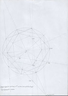
Original penta system.
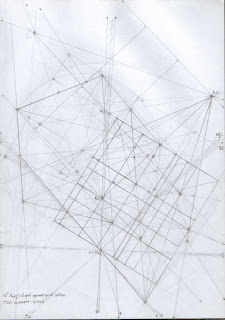
The grid for the system, but the Mavisbank hex system not included.
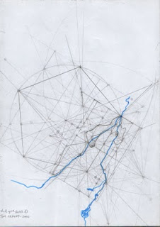
A rough drawing of the horse and rider in its grid, with the two rivers Esk shown.

Original penta system.

The grid for the system, but the Mavisbank hex system not included.

A rough drawing of the horse and rider in its grid, with the two rivers Esk shown.
Subscribe to:
Posts (Atom)
