Monday, 15 June 2015

May 1st 2015 walk - Pilrig House to Holyrood Park

After a year long hiatus, during which the Referendum on Scottish Independence September 18, 2014, and the following Genereal Election May 7th, 2015 both occurred, I got a second-hand Olympus EOS camera with fish-eye lens, and this walk was my first outing with it.  It was a beautiful sunny day and the blossom was at its best.  I walked from a friends house near Pilrig House heading toward Arthur Seat area and Holyrood Park, past Pilrig Church to Holyrood Palace, and the 'face' in the Crags which I mentioned many times previously.  A flowering cherry to start:


Pilrig House:


It would be nice to get a photo from the window in the last of these!  The first line I found in the landscape geometry goes from this house directly through Pilrig Church towards Holyrood:


and across the road from the church is the Boundary Bar, for a few years City Limits but back to the original name:


This spot was found to be a major point in the Edinburgh grid previously described.

A walk along Albert Street and up Easter Road with the Crags beyond and the church at the top also part of the grid to Abbeymount and the Turret, one time a pub now a cafe:


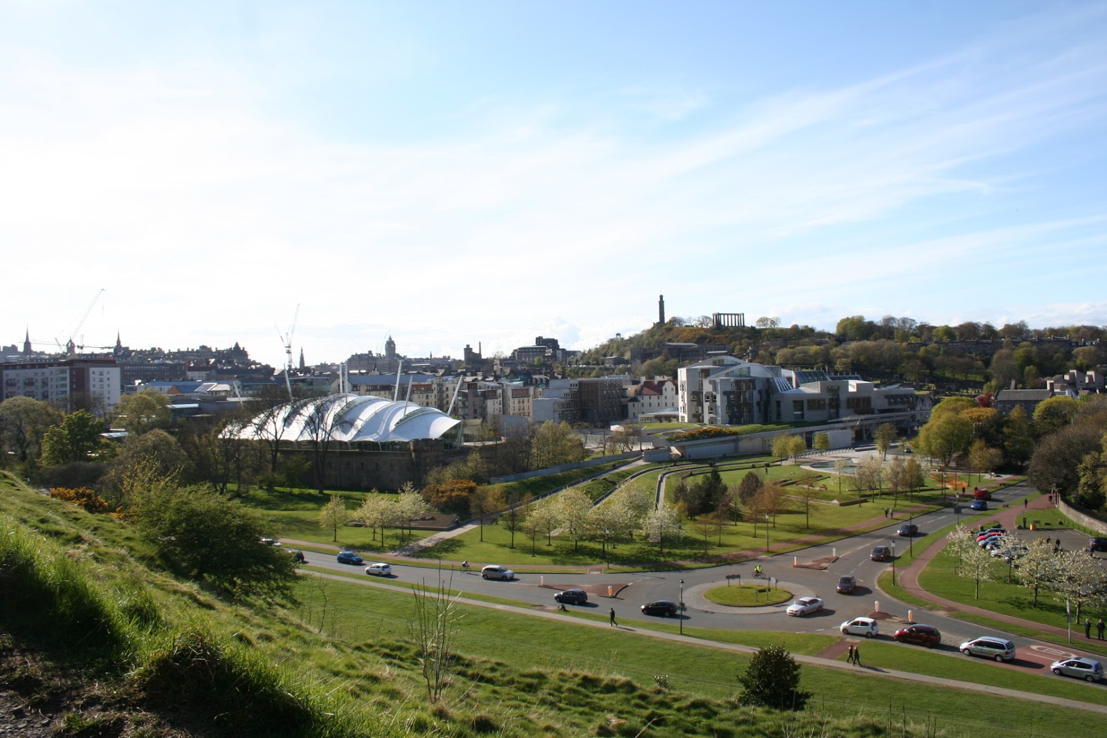
And one of the main reasons for the walk was to get this picture:


depending on how high the new building ends up this view may be lost.


and down under the railway bridge to Holrood:


nice gates but dos anyone see what I see beyond?  Later it 'may' become apparent, lol.  Walking on is a fine unicorn which I use in the header above:


IR5 = King James 5, of Scotland,

and one of the Abbey ruins as we go:


Just round the corner to the Parliament, Dynamic Earth and Sailsbury Crags:


and a first glimpse of the gorse in bloom!

walking into the park and something I have seen for a few years now, but continues to force itself  into my perception and is a integral point in the geometric grid of Edinburgh:


I wonder often how many see it, especially the MSP's sitting gazing out of their windows.  Depending on the time of day and the light it is more or less apparent, but usually recognizable when once seen especially at this distance.  Walking on towards it:


during the referendum campaign and the recent General Election many gatherings where held there and I also wondered how many folk saw this.  The Radical Road slopes up left to right just below the feature.  In fact two people can be seen approaching the feature, giving a sense of scale!


and a couple more with some blossom:


and up the afore-mentioned Radical Road, built by unemployed Paisley Weavers in the early 1800's.  Unemployed due to their radical beliefs, hence the name.  A work scheme proposed by Sir Walter Scott.  The story of the 'radical' weavers and the 'Martyr's' who were found guilty of sedition and transported to the 'colonies',  Gerrard Palmer Skirving Muir and Margorot, commemorated on the Martyr's Monument in the Old Tolbooth Cemetry, the obelisk which can be seen from the North Bridge and Jeffrey Street.  A great song by Adam MacNaughton and sung superbly by Dick Gaughan on his Redwood Cathedral album tells of Thomas Muir of Huntershill, who was transported fourteen years, escaped and died in France:


the Martyr's Monument is to the left, Nelson's Monument is centre and the Old Tolbooth jail and St Andrews House to the right.  Below is the Radical Road:


this is the feature up close, looks like nothing from here:


and a couple of views back down the 'line' through the Palace and a few shots of the Parliament and Calton Hill:


back down the road and further into the park Arthurs Seat comes into view:


some of the gorse blossom:


St Margaret's loch:


St Anthony's Chapel with a bit if fish-eye with a contrail:


and lastly spotted in the carpark, remember this was a week before the election!  And Yes I voted SNP:


fabulous day, a nice walk and my 'new' camera!

Thursday, 5 June 2014

Part 3. Edinburgh grid contd.

The light blue line in these images is the original line from Pilrig House, through Pilrig Church, Calton Terrace, Holyrood Palace/Abbey, the Crags Face, south to the West Edge point at Gilmerton Dykes at Lang Loan. From my notes the bearing is 163.28degrees, which is exact to the hundredth of a degree to the grid established in the previous posts.  Also I have somewhat resolved the issue regarding the discrepancies found making lines in Google Earth.  There is an 'absolute' option available, which seems to resolve the matter, but even that has issues with altitude and viewpoint, in that if not perfectly centred on the image, the line moves in correspondence to angle of view!  I will stick to 'clamped to ground' in the meantime!  At least I am content for now!


The third image above is a close-up of the central area.


This image has both lines plus the town grid alignments, and all are exact to one-hundredth of one degree!


Thursday, 29 May 2014

Part 2 Edinburgh grid geometry continued

continuing with the exploration of the Edinburgh grid:

In the previous post the basic orientation of the street plan of Edinburgh New Town was shown.  My interest was drawn to this originally when it w, as noticed that the line from the pentagram maze at Old Scone was on the line that had started this research over twenty years ago, and that the Craig plan for Edinburgh appeared to be linked closely to it!  When starting from the grid plan orientation it was found that the exact(to the one-hundredth of one degree using Google Earth) bearing (plus 90degrees) from the pentagon at Old Scone passed over Calton Hill, through the Observatory there and is shown in the last image in the previous post, and again below:


Now this line has some interesting points on it, but it is some two-three hundred yards west of my original, and needs some investigation!


The astonishing thing is that this orientation runs straight to Mavisbank eart works which features so strongly in the previous investigation!  This line also includes a hill fort or whatever near Perth, unmarked on GE, and also the main road junction in the village of Scotlandwell on at the foot of Bishop Hill near the edge of Loch Leven, and also Liberton Kirk which is a good sighting point to the south of Calton Hill!


Using Calton Hill to Liberton kirk as a test of what happens more locally in GE a slight discrepancy appears:


so my guess is, its perhaps an artefact of GE, and whether its best to have the lines 'clamped to ground' or relative to ground' which are options in GE.  Relative hights may also be a factor, although Calton Hill and Liberton kirk are roughly equal in altitude, but Old Scone is lower and at a distance of some 45miles or so, the earth's curvature may start to be a factor!?  Something I have wondered about when working at large scale. Straight single lines are not an issue but geometry on the sphere angles become distorted somewhat, and my math skills don't stretch to that!

Thursday, 15 May 2014

Another look at the Edinburgh grid - Part One

(After my old computer 'packed-in' and problems with Google Earth on my old laptop, I again have GE to work with!)

So, starting again from scratch I shall have another look at the Edinburgh grid introduced back in August/November 2012.

This time I started with the streets of central Edinburgh, using George Street as datum, using West Register House dome at the West end of Charlotte Square along George Street, through the statues at the junctions with Castle, Frederick and Hanover Streets and  the Melville Monument in St Andrews Square at the East end.  This also includes the recent erection of the James Clerk Maxwell statue at the east end of George Street.  (My understanding is the Clerk part relates to the Clerks of Penicuik!  More on that later when I'm more sure of the details!)

To the east of St Andrews Square the Bank of Scotland Headquarters (may be the Royal Bank, but I think that is at the top of the Mound!) dome sits on this alignment also.  Calton Hill, where the road bends on the north side, but a good enough sight-line and finishes at the spire of the church at the top of Easter Road at the London Road junction.  The same church I had on my original line which included Holyrood Palace/Abbey, Pilrig church and Pilrig House.

The orientation/azimuth from West Register House being: 73.28 degrees.


The line at ninety degrees is from the Tolbooth Church, the highest point in Edinburgh City(Arthurs Seat being outwith the city proper) down Dundas Street to Tanfield, and includes Assembly Hall(Church of Scotland), the statue atop the RSA(Royal Scottish Academy), and the line of the National Gallery, the statue at the junction of Hanover and George Streets, where lines intersect, azimuth:343.28 degrees.

Same with labels:


This third image shows the James Craig plan as is today:


I'll add an original image of the plan later!

The image below has an exact ninety degree line to the main axis, hence parallel to the other perpendicular, using Calton Hill Observatory, which needs investigation...


....later!

Thursday, 16 January 2014

grid overview

In case the previous series of images was all too complex in terms of grid and units used I include simplified form with the red rectilinear grid centred on St. Mary's chapel and using North Berwick Law as orientation.  The line from St Mary's chapel extends through NBL to the same distance, the 27.7+ miles derived from the Bornholm work, which was found to be the exact same distance as the St Mary's chapel to the Bass Rock(St Baldred's chapel) which was used as the radius of the outer green circle.  The Bass Rock orientation is one degree aprox. east of the shown NBL diagonal, and perhaps could be used in addition to the 'Tavhara'/Roseline(Rosslyn) as described by Bill Buehler, which forms the nearly north/south axis of his 'Reshel' grid, and is shown here (perversely! - ed) in light blue.
When the 45 degrees is subtracted from the NBL line it can be seen to be close to the light blue roseline, both extended as far as Markinch(!) on the outer circumference, and both, plus the Bass Rock line minus 45degrees all cross over Arthurs Seat area, a spread of some two degrees.  Bill allows some three degrees for a 'Selah' spoke,

The grid unit I used in this excercise is one-half of the full 27.7+mile and can be seen to derive naturally from the internal construct of squares and circles.  This unit was originally chosen so I could work on maps back when Google Earth was not available, and was more suitable to the area of geometry I was concentrating on.

The (3 by 1) diagonal the 'reshel' sytem was based is shown in yellow at the bottom and the ninety degree axis from the mid-point of the base is shown in green running nor nor west.  The two (2by1) diagonals to the extremities of the (3by1) set of squares is fron the centre St Mary's chapel are also shown in green.

The Great Pyramid construct with Hillend Fort at the apex is shown in dark blue.  The equilateral triangle lines with apex just short of Inchcolm island are shown  in mauve.  The centre of the pentagonal system used in this excercise is defined by two red lines between these two sets.  (Same as the grid!  I should have changed the colour! TG) This pentagonal system is constructed on the full (3by1) baseline, which is a comparitively recent addition to the system as notified by Bill a while back.  The original used a shorter base and the pentagonal system using that baseline reached Loch Leven in Fife, but was not included in this excercise, but was discussed back in a 2007/8 post when I was just using Ordnance Survey grid references and doing the calculations with a calculator.  Neither pentagonal system is shown here, omitted to allow a clearer view of the grid structure.

This grid has intrigued me since first discovered back in 1999/2000 and re-inforced after the Bornholm work in 2003/4.

How far this grid extends is uncertain, but extensions to Ben Lawers for example and other connections hint that it may extend beoynd the area shown here.  Line of sight points, moutain tops especially, could be used as surveying trig points, and used more locally as centres of construction but that is for an other time!

Also, this grid system is merely one layer of what is altogether too complex (for me, at any rate!), there is still a large backlog of stuff to cover.  My hope was to find that this grid would lead to a simplification of the whole plan, but it hasn't as yet!