Friday, 24 August 2012

First Geometry 1994

Sometime last week I awoke with an image still in mind of when I first realized there was possibly some geometry in the landscape round Edinburgh.  I had been considering using Google Earth to display all my early stuff, described in this blog but using hand drawn or computer graphics and it all too soon got very complicated.  Now that the Olympics are over I can devote more time to this. (Having been side-tracked from my intention of covering the Skellig Michael line mentioned at the end of last post.  More on later!)

Way back in 1994 I had acquired Henry Lincoln's 'The Holy Place' in which he presents his geometry findings in the Rennes Le Chateau area of southern France, coupled with 'The Temple And The Lodge' by his two co-authors of 'The Holy Blood And The Holy Grail', and 'The Messianic Legacy', Michael Baigent and Richard Leigh.

'The Temple And The Lodge' had mentioned Rosslyn Chapel and Temple village, originally Balantrodach, 'Stead of the Warrior' I believe, and also a mysterious head which gazes out at the unwary passer-by down in Roslin Glen, which intrigued me and started me off on my searches of the landscape I had grown up in.  (It is shown in the Header of this blog and is covered in an early post.)


I had also recently become a taxi driver and this enabled me to see the whole area in greater depth and detail, which was a definite bonus!

One day I happened to be coming back in from Lasswade and at the top of a ridge at Gilmerton Dykes there is a T-junction with Langloan which gives a panoramic view of Edinburgh and the Esk Valley and the Firth of Forth and Moorfoot, Pentland and Lammermuir Hills so I stopped to have a look.


To the northeast is Arthurs Seat with Dunsappie on its right flank and Salisbury Crags forming a notch on its left.


Through this notch can be seen a radio mast behind Burntisland in Fife(barely discernible in this photo), and it was when checking this on the map that the first hint of a possible alignment showed!  I found that through this notch Holyrood Abbey/Palace, Pilrig Church and Pilrig House were on a near straight line along with some other interesting points.  The Burntisland radio mast is a bit to the side of the line connecting these three sites from the road junction!


 And in the opposite direction the village of Temple was also included on the line, though not shown here.  More on that later.

While scanning the landscape I noted that somewhere near Caerketton in the Pentlands to the south west would form a right angle(90d) with this line and that somewhere around Carberry Tower/Hill would also form 90d to the north east.  Checking on the map the exact 90d just missed the summit of Caerketton and touched the edge of the Carberry Estate.  It also did connect with Newton Old Church(tower/ruin) and clipped the confluence of the two Rivers Esk(north and south) in Dalkeith Estate, which was to prove important in developing the penta-system described previously.


All good and well, a start has been made, and many months years decades later I can perhaps present my findings in a neater form!  Except I couldn't resist extending the first line to the north to see what turns up!  And needless to say something astonishing happened!  Leaving in suspense till next time!

30th August

As I was saying, doing this in Google Earth I couldn't resist extending the original line north.  This is the first time I have done this, as originally back in 1993/4 G.E. didn't exist, and using only Ordnance Survey maps I was restricted in the area I could examine.  So extending north through Fife and across the river Tay the line passed just east of Perth and passed through the estate of Scone the site of Moot Hill where Scottish kings were crowned.


In these images I have tweaked the line a little to exactly pass through Holyrood Palace, Pilrig Church and Pilrig House, as I had originally found from the maps.
Pilrig House sits in Pilrig Park and is an Old Folks Home now, but was the home of the Balfours(of Pilrig), and I believe included a Prime Minister of Britain, and I found it intriguing that Robert Louis (Balfour) Stevenson was related, and the name is of course used for the hero of Kidnapped, David Balfour, and that Stevenson himself was of the Lighthouse Stevenson's, although chose a career as a writer.


Pilrig church can be seen from Pilrig House, but not much else.  I would like one day to get into the House and look out through the little round window above the front door!


Anyway, it was this alignment which got me started way back in 1994.  I could write a lot more about the early development of the geometry, perhaps more some other time!

What I need to do now is show what I have found from this session with Google Earth as it eventually ties in with what I have doing recently.
As previously said I extended this precise line to Scone and was totally astounded to find:


A direct hit on the Palace/House. Totally unexpected!  Some 18 years after I first got some inkling of a geometric alignment in Edinburgh, and all that I have found since, I now find that original alignment connecting Holyrood Palace with Scone Palace!

Even as I sit here to reflect, I now see that this precise alignment defines the lay-out of the New Town of Edinburgh, which I can not leave unverified! So, let's see what happens when I check this out:


Precise to two decimal degree places, from Carlton Terrace, over Calton Hill and straight along Princes Street, the Holyrood - Scone line on a bearing of 342.61degrees, the three right-angled lines shown bearing: 252.61degrees.  I have included the Old Town Royal Mile from Holyrood Abbey to the Castle and the George Street line from West Register House which goes through Charlotte Square and St Andrew Square.
Thus the New Town grid is defined!  That the New Town runs roughly parallel to the not quite straight Royal Mile was always somewhat obvious, but to be at an exact right-angle to the Holyrood-Scone line I did not realize!

31st August

After posting the above I did play around a bit and came up with some interesting stuff, but shall limit myself to showing just one intriguing finding, for now at least!  In a previous post I made much of a large face in Salisbury Crags near Holyrood Palace which even overlooks the Scottish Parliament, and have often wondered if any of our representatives have gazed out and thought they were seeing things!


Well the original line does in fact cut straight through it, and I had recently taken some more photos of it having noticed this:


The fence on the left is Holyrood Palace, the Sottish Parliament is to the right of where I was standing.  I purposely took this photo from quite a distance because when I show a close-up everyone sees different things(myself included!).  This I think shows the face clearly framed by the trees.


This image shows the Crags Face, with an exact(bearing: 252.61d) alignment to George Heriot's School, with an exact(27.61d) 45degree return to Pilrig, not quite the Church, but where the old Boundary Bar was, but is now called City Limits, directly opposite the Church and the top of Pilrig Street, where Leith Walk proper starts!

A possible exact square with sides 0.98 miles and diagonal 1.38 miles.  I have not included the full square(s), as I want to conclude this exercise and it will take some time to explore the possibilities fully!

I will point out though that this diagonal exactly hits the top of St Giles Cathedral spire:


The observant of those who know Edinburgh may also note that the line from the Face to Heriot's includes the south-east corner of Old College and Greyfriar's Church is in the angle of side and diagonal.  The City Chambers is also on the diagonal across the street from St. Giles, and the National Library is also on the diagonal!

Reminder:  click once on any image and a full screen slideshow will open for better viewing!

Enough for now, I need to return to the main line, but first go drive the taxi for another fun filled Friday night in the Old and New Town!!

5th September

So, just to finish this section I extended this line to the south past Temple kirk with a ouple of high spots for line of sight purposes tp finish some 300yards from Hermitage Castle north of Newcastleton:


and the full line from Scone Palace to Hermitage Castle:


I shall finish here for now!  There's still a lot to be done on this alignment, not least the grid of Edinburgh New Town!  Next I want to look at a slight variation on this line which when extended was quite astonishing!

Thursday, 26 July 2012

Preston (Unicorn) Cross - Callanish extended

I decided to check the extension of the Triangle line from PUC - Schiehallion - Callanish line north west beyond Iceland through Canada and found it reached the Pacific coast near Kelso in Washington State.  This was a surprise as this is the line which cuts through Kelso in Scotland, to the south east of Preston Cross.

Now, I had guesstimated that the line would pass near to Mount Rainier, and it does, which Bill Buehler had also mentioned in his recent post.  What I had not realized is that Mount St Helens lies between Mount Rainier and Kelso.  So this line also runs between two volcanic areas, Mount Etna and Mount St Helens, and of course also includes Iceland.  Quite staggering!  


In the first image another line can be seen coming down through the Great Lakes to Mexico.  This is the other line of the triangle, that is the Lindisfarne, PUC, Inchcolm, Ben Cruachan to Barra line extended, just to complete the exercise.  This line crosses Enhanted Mountain in Texas, and it also cuts through Arkansas, which another researcher, James Tyberon makes much of due to the crystal beds around Mount Ida, although this line is perhaps too far west.


In the other direction, that is south east of Lindisfarne the line extends through Groningen, mentioned previously as the place I lived in for some three and a half years, through Prague, Budapest, Istanbul to near Baalbek.


In my next post I shall comment on the brown line which can be seen in this image which runs from Mount Carmel to Skellig Michael, prompted by J Rankin previously mentioned, but time being short and my brains being scrambled I need a break.

Wednesday, 25 July 2012

acknowledgements

I mentioned that I had started 'playing around' on Google Earth a few weeks back, not for the first time incidentally.  I guess I've spent days if not months in total scanning the planet over the years.  I also mentioned in the first post in this series the 33rd degree west of Giza, and this was after reading Jeff Nisbet's article The Pyramids of Scotland Revisited: http://www.mythomorph.com/wp/the-pyramids-of-scotland-revisited/.  Jeff and I have had some discussion concerning his original article and his interesting hypothesis that the Orion belt stars and Sirius have been laid out in the landscape of Scotland, namely the three islands near North Berwick, with Inchcolm being Sirius.  He also plots the other main stars of Orion.  I found it a fascinating idea, but could not confirm or otherwise as I did not have the resources to check it out.  He also makes much of North Berwick Law being pyramidal and close to the same height as the Great Pyramid at Giza.  That Uri Geller has apparently purchased one of these three islands is fascinating!  He also mentions Doggerland in the above article which added to the interest when the BBC article appeared synchronicitously  (I perhaps have just made this word up, spell-check doesn't like it, but I don't really care! lol!)

Anyway I plotted the 33rd degree west of Giza, prior to Bill Buehler's new systems appearing and the connection with one of the Michael ley lines at Stanton St Bernards in the first post of this recent activity.

So I thank Jeff for bringing it to my attention, and apologies for not mentioning this in that post.  Quite honestly I was 'off on so many tangents' by that time my head was spinning!

Also, thanks to J Rankin whose site I came upon when checking the Michael ley, who also mentioned Doggerland and Heligoland in particular.  http://thothistheibis.wordpress.com/2012/05/27/the-bush-barrow-treasures/  A fascinating, informative article I fully intend to return to.  A line from Skellig Michael to Mount Cramel is also mentioned and because of the link to Skellig Michael I also plotted on Google Earth, it's the brown line in some of the images, but I have not had time to write it up yet!


So thanks again to both!   

Tuesday, 17 July 2012

Google Earth exercise contd.

 The projection of some of the lines in the previous posts left me dumbstruck, and I feel the need to show the most relevant.

The last few weeks certain topics drew my attention, namely new information about Doggerland, in what is now the North Sea, and last week a four night series of programmes on B.B.C., called Volcano Live  .http://www.bbc.co.uk/programmes/p00tmqdr

Doggerland
This is a link to the BBC article:  http://www.bbc.co.uk/news/uk-scotland-edinburgh-east-fife-18687504


Doggerland has long intrigued me!  The geometry I have found is restricted to dry land, where sites can at least be marked, checked and visited, and some of these are ancient, and so it is possible that the geometry did cover parts if not all of the land subsequently lost.  There are certain points which do occur in what is now sea, but may once been land, for instance the area around Inchcolm has a few, but presumably the area around the island would have been dry a few thousand years back.


from the BBC article.


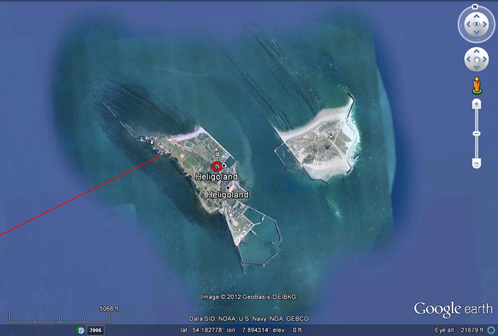
A nice blog by J. Rankinhttp://thothistheibis.wordpress.com/2012/05/27/the-bush-barrow-treasures/ in which Doggerland is mentioned and the Michael Ley extended towards Denmark and mention made of the island of Heligoland situated off the corner of Denmark and Germany, which I plotted on Google Earth:


The red line from Mount St Michael, bottom left running north-east to the bottom of Denmark with Heligoland marked (click on the image to get a full screen shot)


Also in this image are extensions to the south-east of the special triangle previously mentioned with its apex at Preston (unicorn)Cross, P.U.C.   The most important at this time is the extension of the Callanish - Schiehallion line through PUC and Kelso which cuts the Michael Ley near Yarmouth and extends down to Mount Etna on Sicily, one of the presently(last week) fourteen active volcanoes listed on the BBC Volcano Live programme.


That was interesting in itself, but the extension to the north-west skirts Rejkyavik(sp) and at least two major volcanoes on Iceland, Katia and Hekla, ending at Snaefelljukull, presumably also volcanic!?.  Very surprising, and raises the question whether this is the reason for that particular line!?


I then checked the blue line which originates at Bugarach mountain and connects with the Barra point of the triangle and was one of the two original plots in the previous post, as it too appeared to be heading for Iceland.  Two volcanoes again, the first the volcano which caused so much disruption to air traffic in 2010, Oraefjelljokull(sp?), and Boroarbunga at an impressive 6000+ft.


Stunned by these findings I happened to zoom out to get an overview and became attracted to a yellow feature appearing on the horizon in the Pacific ocean and guessing this to be Hawai I noticed that the dark blue line may extend to it.  And it did!


As can be seen the line crosses Greenland and northern Canada which I have not investigated yet.


The Hawaian islands, like Iceland, owe their existence to volcanic activity, and the BBC team based themselves there for the series.


In his most recent post Bill Buehler had linked Hawai with the Rennes Le Chateau area, and here is a direct connection which I had not even guessed at when I chose this particular line, with Iceland as bonus, and the Barra link to the specific triangle I have made so much of in previous posts, and Iceland and Mount Etna on the Callanish - Schiehallion -PUC hypotenuse of said triangle.  I recall also Bill commenting that the Callanish - Barra alignment was very special in his systems a good many years back.


I await Bill's upcoming website before attempting to describe his work further as I am in no way competent   
to even begin.  What I can say is that for some 13 years now the geometry I have been researching has interlinked in many surprising ways, often in seeming synchronicity, as with this exercise!


Bill also mentioned Antartica in his latest post, and The Volcano Live team had a piece on Mount Erebus, a Cambridge team goes there every year to study Erebus, and I found it in what is described as Hot Point Peninsula.  I extended the line and it does cross Antartica but a good way off Erebus:


As can be seen it passes to the east of New Zealand, also mentioned as having volcanic activity in Volcano Live, and what appears to be a long deep trench running parallel to this line, again I have not yet searched this part.


To conclude this exercise I completed the line back round to Bugarach checking that the projection was accurate, completing a Great Circle:


As can be seen the line is about as long as a line can be drawn across Africa, and includes The Congo which contains another volcano covered in Volcano Live, but I was unable to find it, forgetting its name even, but I did find one in Chad, but not very close.


Completion of the Circle, with Menorca and Girona in line:
There's still more to describe but later.

Friday, 25 May 2012

Four Michaels in Google Earth and William S. Buehler connections

For the past six months or so I've been working with a free CAD system called Cademia, and can plot points accurate to the metre covering the entire Ordnance Survey grid area of the UK and a part of Ireland, important though as the area round Newgrange and Tara can be included.  A pity in that Skellig Michael, Mont Saint Michel and Carnac are outwith the limits of the grid.  (Also, I can only save files in PDF format and I don't quite know how to publish these yet.)

This is unfortunate as recently I have been drawn to these points, and even south as far as Santiago de Compostela and the Rennes le Chateau area, and east to the Baltic, Bornholm and Gotland in particular.  I have had to resort to Google Earth to cover this and was quite happily working on this when a post appeared from William Buehler showing some new systems which interact with what I'd been working on to an astonishing extent, that I need to try and cover this.  As it is so long since I've been posting and the format of Blogger has changed a bit, I'll keep this short and make sure I can post some Google Earth shots.

If this works an overview of the area should show:


Ok, that was simple enough!  Click on the image to open a full screen view, and slideshow of all images used.

The image shows the Uk/Ireland and France down to the north of Spain, and two lines heading east to the Baltic area.

The prominent yellow vertical line is the Greenwich meridian.

The red vertical line to the left is the meridian of a feature I found just south of the stone fields of Carnac, the tumulus Saint Michel, and was originally traced through the UK all the way to Orkney, and runs through my main area of interest namely Edinburgh and Midlothian with many points of interest noted.  I subsequently extended this south to the latitude of Santiago de Compostela, as I had found a line from there through Mount Saint Michael in Cornwall extended north east to the south Scotland area, more on later!


I accurately plotted a line due east to Tumulus St Michel meridian, then extended this east again accurately the same distance which was in the Rennes Le Chateau area  to a point close to the mountain of Bugarach.
(Actually, I had previously noted that visually RLC appeared to be close to the mirror point of St de Compostela.  Drawing the line from RLC to the point where The St de Comp. line had intersected the Tum St Michel meridian, extended to Tinto Hill in the South of Scotland, which is a prominent pyramidal hill and is finally coming into the picture, linking to the Glasgow stuff mentioned previously.)


I decided to use Bugarach mountain as the nearest and best point to use for a large scale projection, being a prominent line of sight point and is a major point in the geometry of both Henry Lincoln and David Wood, if memory serves right!(They both use Bugarach church which is in the village of Bugarach - 13-6-12).  The results were astonishing, in themselves, but they also connect with Bill Buehler's new systems at certain points.
My first two trials proved to be inspired, and connect Bugarach with Callanish and Barra( which also includes the exact summit of Snowdon, the highest mountain in Wales), both corners of the triangle with Preston Unicorn Cross at its eastern apex.  More on later.

My initial spur was reading recently that Skellig Michael, Mount Saint Michaels and Mont Saint Michel where in a straight line.(see Article 'Lands End or Beginning' - Andrew Gough link in list opposite).  I find them to be in a near straight line, and I have put in the line from Skellig Michael(Great Skellig?) direct to Mont Saint Michel, and also the lines from Mount Saint Michaels to both of these, and at a great scale as in the first image, seem to be the same.  It still is intriguing, (is it not?) that three such impressive rock islands all with structures on their tops dedicated to the same saint, or saints with the same name, should be so closely aligned.

Scanning the Carnac area I then came across Tumulus Saint Michel, and used this as the exact longitude to use for the exercise extending Carnac's longitude north, as it sits roughly between the extremities of the visible stone fields a little to the north.


After this I zoomed out and noticed that the tumulus seemed to be the same distance from Mount St Michaels as Mont St Michel is.  On checking, the distances were 206.11 miles and 206.24 miles, respectively!!  Just one more astonishment!


Four St Michaels showing geometric relationships!


I joined the tumulus and Mont St Michel, and then extended north east to the island of Gotland, finding that not only did it skirt both Amsterdam and Copenhagen, but also the town I lived in for some three years, Groningen in the north of the Netherlands.  Of personal interest, perhaps more later.

The other line heading to the Baltic, Mount Saint Michaels to Bornholm was to see if this correlated with the well known Michael/Mary line much commented on by others.  Bornholm is a major centre of geometry verifiably accurate to within millimetres using the Danish Kort &Matrikelstyrelsen data as shown by Erling Haagensen and Henry Lincoln and looked at by me earlier in the history of this blog.

Although to the south of the Michael/Mary line there is enough to be intriguing. Not least finding the intersection with another line of longitude I had been interested in, again read about recently, the line of longitude 33 degrees west of the Great Pyramid.at an estate/hamlet called Stanton St Bernards which I did not know of previously.  Not only did one of Bill Buehlers lines also pass through this spot, but also the line from Bugarach to Barra,   My 'gast' was truly 'flabbered' by now!


In this image Stanton St Bernard can be seen in relation to the Milk Hill area, and some of Bill's systems with sites of previous crop formations indicated.  The line from Mount St Michael to Bornholm goes directly through one of these formations labelled 'Whale'.


A close up of Stanton St Bernard.

6-6-12 update!

First a couple of shots of what I've been doing in the Rennes Le Chateau area:


this is my first attempt at constructing David Wood's( GENISIS and GENESET) pentagonal system, still not 'right', needs tweaking!

Also I've played around with colours a bit, and there is an additional purple line which is the 'Great Circle' line between Santiago de Compostela and the Rennes area, see the third image !


This second one shows again my first attempt at constructing Henry Lincoln's(The Holy Place etc) pentagon superimposed on Woods system.


The Great Circle, or shortest distance between two points on a sphere, in purple, as opposed to the three points of same latitude I used for initial construction, in red!  The difference is noticeable, and more on later.  I also picked out some points of interest on the way, Montsegur and Lourdes, although not on the lines concerned, but good for future reference!

Now another WSBuehler connection!  I had gone back to the Callanish and Barra areas to construct the triangular system with Preston Unicorn Cross at its apex, desribed previously. plotting relevant points of interest, namely Cruachan, Ben Ledi, Inchcolm and on through to Lindisfarne on the Barra line, and Schiehallion on the Callanish line in particular, and as Mount St Michaels was a prominent spot in this whole story, plotted the line between Schiehallion and Mount St M's to find that it connected with the UK Grail Resh point of WSB's, just off  the Anglesy oast.  It also ran through the Isle of Man, and the centre of Glasgow, including the Science Park, BBC and Kelvingrove Museum, all worthy of note!


Where the two turquoise lines interset is Preston (Unicorn) Cross, (PUC)and the extensions to the east and south-east terminate in this image at Lindisfarne and Kelso respectively.  The return line from Lindisfarne through Kelso extends to Ailsa Craig and is further desribed below.

This image shows the Callanish - Barra section of the PUC triangle as used by me for the calculations described earlier in this blog.  The two different blue lines are from Bugarach.  The red line running parallel to the linking line between Callanish and Barra from the south is from Skellig Michael, just one more link to consider.


A section of the Barra - Lindisfarne line showing Ardchattan with the Bugarach - Callanish line and intersection with the Cruachan massif to the right with Loch Awe spanning the gap between the two lines.


In this image, Inchcolm is to the left and Preston (Unicorn) Cross at the intersection with the Tumulus St Michel longitude, in red, midway between PUC and Arthurs Seat.


Inchcolm with the line passing through both Abbey and highest point.


The extensions of both lines to Lindisfarne, at the end of the Barra line with the 33d west of Giza longitude in the gap between the island and mainland, and Kelso, (Abbey area), on the Schiehallion - Callanish extension,  with the line from Santiago de Compostella - Mount St. Michaels running through to form a near 90d angle with the Barra line!


In the above and below images, the line joining Lindisfarne and Kelso is shown extending south-west and taking in Dryburgh Abbey and also the Eagles Nest point much emphasised in this blog, with the tumulus St. Michaels longitude running just east of Eagles Nest, and with Lee Pen at Innerleithen marked.  This line continues south-east through the Dryhope Tower area to Ailsa Craig, the island where granite Curling Stones are from.


The Kelso area with Kelso Abbey , the octagonal ?bandstand? in the town and Roxburghe Castle ruin to the left.


The Eagles Nest and Dryhope Tower  with St Mary's Loch and the Yarrow valley. with the Tumulsus St Michel longitude in red.


Ailsa Craig.  The red line continues through Donald's Hill in Ireland.


I shall leave this as is for now, although there are a lot of connections to try.  One that I did try was Mont St Michel through Glastonbury Tor another Michael connection, and extended was close to the Callanish area, which did include Goat Fell on Arran, a prominent mountain in west-central Scotland, but the line ran just east of Glastonbury Tor, and clipped the north-east coast of The Isle Of Man.  Trying Snaefell on Man brought The Great Orme on the Welsh north coast into the picture, and a direct line through Glastonbury Tor summit finds the centre of the Great Orme.  I haven't included this yet due to time constraints and developing complexity.

I could include more images/text as and when deemed necessary.

This exercise has been an astonishing journey, but then what's new? TG - 15 June, a week till solstice!